Table of Contents
Online Help > Maps & Layers
Maps & Layers
The application is able to display a wide variety of maps. They are made of images, each level of details consisting of a different set of them. Using images allows to have a larger variety of maps, with a better quality, more details, and use little power consumption (and so battery).
There are two main categories of maps, that can be both used without network:
- On-demand maps are maps retrieved on-demand from Internet and automatically stored on the device;
- File-based maps are maps stored in pre-created files, saved on the device, covering a particular fixed area. The application is able to read multiple file formats.

The Maps & Layers menu
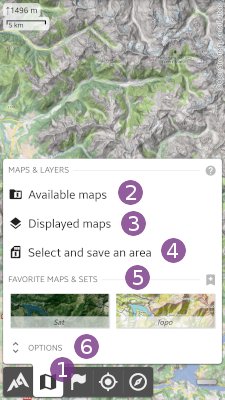
Tap the “Maps & Layers” ![]() menu button to display the menu that contains:
menu button to display the menu that contains:
- “
Available maps” opens the maps explorer to manage all available maps and add some more;
 - “
Displayed maps” allows you to list and manage all currently displayed maps (remove, reorder, change opacity, edit color, erase color, etc.);
 - “
Select and save an area” , only available if at least one on-demand map is displayed, allows you to store on your device a complete map area of one or multiple on-demand maps;
Tap on “Options” ![]() to display the maps options:
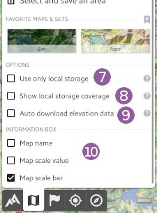
to display the maps options:

- “
Use only local storage” forces the application to go offline: no map data is downloaded anymore, even if the displayed area is not stored;
 - “
Show local storage coverage” displays on-screen information concerning the stored areas (only available if at least one on-demand map is displayed);
 - “
Auto-download elevation data” makes the application automatically download elevation data for the current area (only available if the elevations feature is activated);
 - “
Information box” allows you to select what to display in the top/left maps information box.
On-demand maps
When a map is selected from the available maps list, the application will download, display and store on the device all displayed areas. Everything that has been displayed once remains stored and available for off-line use. When the same area is displayed again, the application will use the stored data instead of downloading it again (unless the stored data is too old and a new version can be downloaded).
Managing maps list
The application offers a wide range of maps, with some being pre-installed by default. You can remove them or install new maps from the community maps list, an extended set of maps mostly suggested by users. Note that the community maps list is regularly updated and can change without warning.
How to select another map?
How to add another map as a layer?
How to add maps from the community maps list?
How to update maps from the community maps list?
How to suggest a new community map?
How to create a custom map?
Managing stored data
The application also offers the ability to store a larger area than the one displayed, see how to store a complete map area for offline use. In order to store temporary data or store data in various locations, see how to use workspaces.
How to store a complete map area for offline use?
How to check the availability of locally stored data?
How to clear stored data?
How to store temporary data?
File-based maps
File-based maps are pre-created maps copied on your device. Some key features are:
- They can be created at home, using a hi-speed Internet connection, which is usually faster than a mobile connection;
- They consist in a single file, which can be easily copied to or removed from the memory card. They can be easily exchanged over Internet;
- They have clearly defined bounds that makes clear which map is available at which location.
However, with the always increasing connection speed and capabilities of mobile devices, several weaknesses compared to on-demand maps make them part of the legacy:
- The data cannot be updated, they become obsolete after some time;
- The area cannot be extended, if a larger area is needed, a new map must be created and used;
- The entire file must be on the device, even if only a small subset area is needed;
- It can take long time to move the maps on the device.
How to use file-based maps?
How to import KML/KMZ map overlays?
How to calibrate an image to use it as a map?
How to create file-based maps for the application?
Maps features
How to create favorite maps and sets?
How to modify the opacity of a map or layer?
How to modify the color (contrast, brightness, saturation and tint) of a map or a layer?
How to erase a color from a map?
How to switch between two maps in one click?
How to deal with multiple maps covering continuous areas?
How to export the displayed map as an image or to print it?
How to correct offset error of some maps over China?
Maps F.A.Q.
How often are the maps updated?
The application only display maps available from various online sources. Map updates only depends on the map editor of the map you've selected. In general, the application will display the last available version. For example, if you display the Google Satellite images, you'll see the most recent images available on the Google Maps website, however, those image can still be relatively old depending on the area displayed.
Is it possible to display real-time aerial imagery?
No, the application allows you to display the latest version of major online maps, including Google, Bing, Esri imageries, but you cannot choose a different date, nor display more recent images than the respective website versions. The stored data is regularly updated by the application when newer versions are available online.
Is it possible to increase the download speed of maps?
Each map uses its own map server and has a different download speed. Various factors can impact the download speed, including your physical location and the current server charge. We try to keep the default map as fast as possible to download, but don't hesitate to select another map that may be faster for you to access. If you need to download lot of map data, try to avoid rush hours to get a better speed.
Is it possible to change the language of names displayed on the maps?
Each map has its own policy concerning how to display names. The default map uses the local language (i.e. localized names) so all users have familiar names displayed in their own languages. Other maps like Bing Maps only uses English names everywhere. You can also install an alternative version of Google Maps or Bing Maps displayed in various other languages, just install the community map called “Google Maps (Localized)” or “Bing Maps (Localized)”.
Is there a size limit for the file-based map files?
Yes, on older devices. Android versions smaller than the 3.0 cannot manage files bigger than 2GB. On those versions you will get errors while displaying parts of the maps which are stored after this size limit. Starting with Android 3.0, you will be able to read bigger maps correctly.
Problems with maps
When displaying an on-demand online map, I'm only getting the error message “SSLHandshakeException”
It probably means you're using a quite old device (Android 4.4 or less) which is unfortunately not compatible anymore with the more recent security protocols requested by this map. This only solution is to use a device with Android 5.0 or more. If it's already the case, please contact us by email to report this map.
What if no maps are displayed, zooming a lot displays “Area not stored”
It means that you've activated the “Use only local storage” mode that prevent the application to download any new map data. Just deactivate this mode as explained here.
What if some maps have an offset error over China
Following Chinese regulations, most maps are intentionally distorted over China. As explained here, the application is able to correct this distortion.
What if an on-demand map is not working anymore?
First, be sure to get the map again from the community maps list, in case it has already been fixed or updated.
If it doesn't help, don't hesitate to contact us, but please keep in mind that we may remove any community map if it can't be fixed.
What if a MemoryMap map doesn't work?
The application doesn't support the new MemoryMap format (“*.qc3” file extension), as well as encrypted maps. You can use the free Lite version to check if your maps are compatible.
