Table of Contents
Online Help > Placemarks > Target
The target location
When you set a location as the current target, the application will give you various information related to this location based on your current location, most importantly it's distance and direction.
How to set a location as target?
To set a location as the current target:
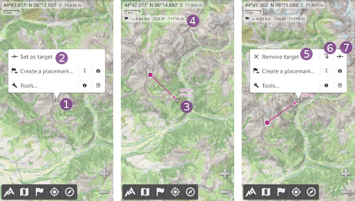
- Move the map center point over the location you want to set as target, and tap it
 to display the map center menu;
 - Tap
Set as target ;
;
When you move the map center point over another location, an oriented line will be drawn from this new location toward the target location ![]() . Various text information will also be displayed based on the context.
. Various text information will also be displayed based on the context.
An information box ![]() is also displayed, with the straight line distance and azimuth from the map center location toward the target location. If both locations have known elevations, the elevation difference is also displayed.
is also displayed, with the straight line distance and azimuth from the map center location toward the target location. If both locations have known elevations, the elevation difference is also displayed.
![]() A small arrow reminds you that the information is always given from the center location toward the target location.
A small arrow reminds you that the information is always given from the center location toward the target location.
In order to remove the target or change it, tap on the map center point again ![]() :
:
- Tap
Remove target to remove the target;
 - Tap the
Jump to icon to move the map center location over the target location;
 - Tap the
Set as target icon to replace the target location with the current map center location;

How to get the target distance along a path?
If you have a path displayed on the map, and want to know the distance along this path, from the map center location to any of its locations:
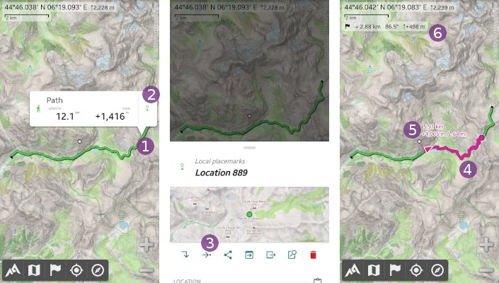
- Tap on the destination path location
 ;
; - Tap on the location icon
 (do not tap the path icon or name);
 - In the sliding menu, tap the
Set as target shortcut icon;
 - If you move the map center point close enough to the path, the section going from the closest location to the destination location will be enlightened
 , and its distance will be displayed at the map center
  (depending on the information available, the cumulated elevation gain and lost can be given, as the “ETE” and speed used to compute the “ETE”).
![]() The information given at the map center only takes into account the enlightened path section, and not the dashed line section from the map center point to the closed path location.
The information given at the map center only takes into account the enlightened path section, and not the dashed line section from the map center point to the closed path location.
![]() The information given in the target information box
The information given in the target information box ![]() remains the straight line information.
remains the straight line information.

How to change displayed target information?
You can change which information is displayed about the target:
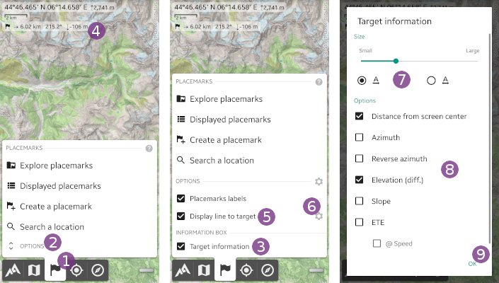
- Tap the
Placemarks menu item;
 - Tap
Options ;
; - Un-check the
Target information checkbox to hide the target information box
  ;
; - Un-check the
Display line to target checkbox to hide the line from the map center location toward the target location;
 - Tap the wheel settings icon
 to change the information displayed on the map center point, including the size and alignment of texts
  and the information displayed
  (see below);
 - Tap
Ok to validate.
Available information is:
Distance from screen center: the distance from the map center location to the target location;Azimuth: the azimuth (direction) from the map center location location to the target location;Reverse azimuth: the azimuth (direction) from the target location to the map center location location;Elevation (diff.): the target location elevation minus the map center location elevation, if both locations have known elevations (intermediate locations are not taken into account);Slope: the mean slope computed from the map center location to the target location, if both locations have known elevations (intermediate locations are not taken into account);ETE: the “Estimated time en route”, which is the time needed to go from the map center location to the target location, at your current speed;Speed: the speed used to compute the “ETE”.

