
I've just purchased AlpineQuest to hopefully replace MMTacker (which I use for UK hiking) and OruxMaps (which I use for hiking abroad). AlpineQuest seems to be the only alternative if I want to use my MemoryMap maps and a great one at that.
Two of the main advantages over MMTracker are : moving off one map when browsing results in the next map being displayed (not so in MMTracker) and height gained/loss profiles. I also suspect that Alpine Quest will be able to load external GPX files from different sources more reliably though I haven't tried this yet.
The initial downsides (at the moment) are :
1. Waypoints seem to be the same colour as the tracks. I have a waypoint set of Wainwrights which I load in and aim for when in the Lakes. As they load in as the same colour are the track they become almost invisible as you move over them. I know I can manually change an individual waypoint colour but can I change the colour of a who set of waypoints? Could waypoints have their default colour user-defined?
2. In both Orux Maps and MMTracker there is the option to create GPX files from recorded routes automatically. I know I have to export them myself Would it be possible to add an option to automatically create a gpx file (as well as the native track file)?
3. I would like to keep GPX routes and Waypoints in a directories of my choice - I haven't found how to change the default directory where they go. Is this possible? MMTracker is ideal for me - one starting the app you are asked to set the directory for Maps, Tracks, Waypoints and Routes (all treated distinctly)
4. The arrow used for the location of the user - is this changeable to be something a little less solid? e.g. crosshairs
I'll be off hiking in anger this weekend and look forward to trying the app in real life - and discovering options I have never had before..... thanks for creating it.
The support forum is temporarily read-only. For urgent requests, please email contact[at]psyberia.net
[closed] Initial Feedback & Questions
-
Searcher2
- Posts: 12
- Joined: Fri May 20, 2016 6:11 am
Re: Initial Feedback & Questions
Well I've had a couple of walks and really like the ability to get a height gained/lost profile of the walk on AlpineQuest. I'm still struggling with loading previous tracks in and removing them (I tried deleting all the imported Displayed landmarks but the old track still remained until I closed the app and restarted). I need a little more experience with it I think.
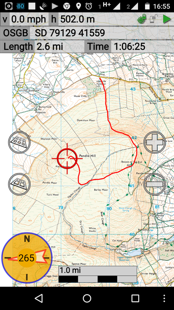
One thing that I did notice was that the maps were not as clearly displayed in AlpineQuest as MMTracker at more zoomed out levels (zoomed in levels are fine). I took some screenshots from roughly the same position at the same level of zoom. You can clearly see the difference.... and also what I mean about having a cross hair rather than an icon which covers the point which you are actually at - especially when the direction arrow is over that point. You can also see the Compass on MMTracker is 'out of the way' when permanently displayed. On AlpineQuest when permanently displayed it obliterates the current position.
MMTracker
AlpineQuest
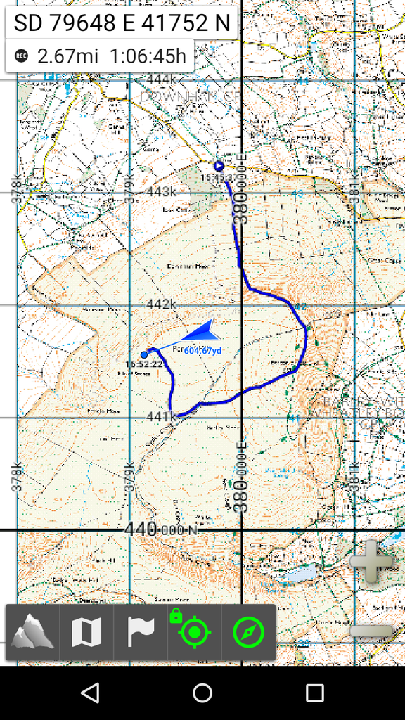
Both screenshots are from the same phone - Moto G Gen 2.
Obviously AlpineQuest is can handle more than just QCT files and that is a great advantage. It would be better if it could display the QCT more clearly at these zoom levels.
One thing that I did notice was that the maps were not as clearly displayed in AlpineQuest as MMTracker at more zoomed out levels (zoomed in levels are fine). I took some screenshots from roughly the same position at the same level of zoom. You can clearly see the difference.... and also what I mean about having a cross hair rather than an icon which covers the point which you are actually at - especially when the direction arrow is over that point. You can also see the Compass on MMTracker is 'out of the way' when permanently displayed. On AlpineQuest when permanently displayed it obliterates the current position.
MMTracker

AlpineQuest

Both screenshots are from the same phone - Moto G Gen 2.
Obviously AlpineQuest is can handle more than just QCT files and that is a great advantage. It would be better if it could display the QCT more clearly at these zoom levels.
-
Yemble
- Posts: 333
- Joined: Sun Apr 28, 2013 5:02 pm
Re: Initial Feedback & Questions
OSGB is available as a Community Map (1:50k & 1:25k delivered from BING servers). The display quality of the native AQ map is rather better than your screen shot. It is possible to aquire a full offline map of the UK in both scales in native AQ format, free of charge. However, it takes a lot of time and patience and occupies over 70Gb. Once you have it, you never need to run in on-line mode again! I know this because I have done it 
-
Searcher2
- Posts: 12
- Joined: Fri May 20, 2016 6:11 am
Re: Initial Feedback & Questions
Thanks Yemble. I was rather hoping to keep using the QCT maps I already have at 1:25K. They occupy less than 16GB for the whole of the UK so considerably less than the 70GB you mention. It's not like it's impossible to use as they are but I was surprised at the difference between the 2. One more zoom level in and the text on the maps becomes a lot better and another zoom level after that it is fine cf MMTracker.
-
Psyberia-Support
- Site Admin
- Posts: 6407
- Joined: Wed Apr 14, 2010 9:41 pm
Re: Initial Feedback & Questions
Hi "Searcher2" and thanks a lot for your interest in this application and taking some time for it.
I'm very sorry for the delay of my answer.
Don't hesitate to have a look at the online help, especially the page on the track recorder if you've issues stopping it: http://www.alpinequest.net/en/help/v2/tracker
But don't hesitate to ask all your questions here.
For the point 1, yes all "landmarks" (that how I call all items you can put on the maps like waypoints, routes, tracks, etc.) have the same default color, except for the track being currently recorded which is blue. You can change the default color in the application settings, in the "Landmarks" section - "Display color".
However what you can do if you want your waypoints in another color without having to modify them all one by one, is to use "waypoints sets". You'll then be able to choose a color (or an icon) for the set, and all contained waypoints will be displayed in that color. If you've already created your waypoints, you can copy them all (from the "Waypoints" category menu) and paste them in any folder to group them. Let me know if you need more details about that.
For 2, there is no such option is AlpineQuest. The previous 1.4.x versions had something like this (the format was asked when stopping a track), but it was more complicated than anything, so it has been removed in the 2.x versions. The vast majority of users just keep recorded tracks in the application (as you can get all the stats you need), so now the application automatically saves tracks in its own format (much faster to read/write and contains more data like accuracies, pressures, styles, etc) without asking any question.
However you can export any track in the GPX in few (3) clicks, so its very easy: http://www.alpinequest.net/en/help/v2/t ... ded_tracks
For 3, again it's not possible (sorry ! )... You can change the main application folder from the application settings, but then the application uses fixed folder inside that one. Recorded tracks are in the "[app folder]/landmarks/Recorded tracks/", and exported tracks (GPX files for example) are in "[app folder]/landmarks/Exported landmarks/".
Again, I believe (because you're the first one to ask that) that most users don't care about using particular folders, so my opinion is that there is not need to bother users with those kind of questions when starting the application.
But if you tell me that it's important for you, I can add a setting for that. The application has something called "user settings" allowing a finer control than what can be changed from the main application settings, so if you want I can add users settings to configure all the application folders.
For 4, still not possible, however it's planned for soon. You'll be soon able to change the center screen icon and I'll also see what I can do for the current position icon. Note that a "crosshair" is good to point a location, but it doesn't show any direction...
For the display quality of QCT, you should try to change the "Map display resolution" in the application settings instead of zooming out too much. If it doesn't change anything please let me know, but I find strange that even the recorded track has a poor quality, so I think there's something strange with the resolution.
I realize that both apps are quite different and that it doesn't make things easy for you... In a way it's a good thing, having so much different applications allows everyone to find the one that best suit its needs...
I'm very sorry for the delay of my answer.
Don't hesitate to have a look at the online help, especially the page on the track recorder if you've issues stopping it: http://www.alpinequest.net/en/help/v2/tracker
But don't hesitate to ask all your questions here.
For the point 1, yes all "landmarks" (that how I call all items you can put on the maps like waypoints, routes, tracks, etc.) have the same default color, except for the track being currently recorded which is blue. You can change the default color in the application settings, in the "Landmarks" section - "Display color".
However what you can do if you want your waypoints in another color without having to modify them all one by one, is to use "waypoints sets". You'll then be able to choose a color (or an icon) for the set, and all contained waypoints will be displayed in that color. If you've already created your waypoints, you can copy them all (from the "Waypoints" category menu) and paste them in any folder to group them. Let me know if you need more details about that.
For 2, there is no such option is AlpineQuest. The previous 1.4.x versions had something like this (the format was asked when stopping a track), but it was more complicated than anything, so it has been removed in the 2.x versions. The vast majority of users just keep recorded tracks in the application (as you can get all the stats you need), so now the application automatically saves tracks in its own format (much faster to read/write and contains more data like accuracies, pressures, styles, etc) without asking any question.
However you can export any track in the GPX in few (3) clicks, so its very easy: http://www.alpinequest.net/en/help/v2/t ... ded_tracks
For 3, again it's not possible (sorry !
Again, I believe (because you're the first one to ask that) that most users don't care about using particular folders, so my opinion is that there is not need to bother users with those kind of questions when starting the application.
But if you tell me that it's important for you, I can add a setting for that. The application has something called "user settings" allowing a finer control than what can be changed from the main application settings, so if you want I can add users settings to configure all the application folders.
For 4, still not possible, however it's planned for soon. You'll be soon able to change the center screen icon and I'll also see what I can do for the current position icon. Note that a "crosshair" is good to point a location, but it doesn't show any direction...
For the display quality of QCT, you should try to change the "Map display resolution" in the application settings instead of zooming out too much. If it doesn't change anything please let me know, but I find strange that even the recorded track has a poor quality, so I think there's something strange with the resolution.
I realize that both apps are quite different and that it doesn't make things easy for you... In a way it's a good thing, having so much different applications allows everyone to find the one that best suit its needs...
Do you like AlpineQuest ? Leave a small comment on Google Play !
-
Yemble
- Posts: 333
- Joined: Sun Apr 28, 2013 5:02 pm
Re: Initial Feedback & Questions
The Community OSGB map includes zoom levels 3,5,7,9 and 11 (which is the 1:250K Road Atlas) from OpenData and levels 12,13,14 and 15 from BING (the first three are 1:50K and the last is 1:25K). All are displayed in high res. It is a nice map set and well worth the effort aquiring it all, if you have a spare 128Gb microSD, lots of patience and plenty of time on your hands (check out this post: viewtopic.php?f=5&t=2177)Searcher2 wrote:Thanks Yemble. I was rather hoping to keep using the QCT maps I already have at 1:25K. They occupy less than 16GB for the whole of the UK so considerably less than the 70GB you mention. It's not like it's impossible to use as they are but I was surprised at the difference between the 2. One more zoom level in and the text on the maps becomes a lot better and another zoom level after that it is fine cf MMTracker.
Your comment about the physical map sizes is a valid question and one that I asked myself. The answer is mainly to do with the way that MM and AQ store their map data, MM is a set of discrete area files whereas AQ is a database. MM is far more efficient at storing the equivalent map data, however, AQ is faster at displaying the map and there is no delay when panning around. These days, storage is cheap, so I vote for AQ
If you want some pointers, please let me know.
I started off with a set of MM maps when I first started using AQ, a few years ago, but soon abandoned them due to performance and display issues.